


swisstopo VR app for iPhone and iPad
Developer: Ateo
First release : 16 Feb 2017
App size: 247.21 Mb
The Swiss Federal Office of Topography (swisstopo) is working towards presenting the 3D geodata from its topographical landscape model of Switzerland, swissTLM3D, to a wide audience and thereby introducing alternative ways of displaying geographic information.
- swisstopo VR – “virtual reality” geodata -
Thanks to modern media, 3D technology is now available everywhere. 3D visualisation technology is being researched and further developed first and foremost in the film and entertainment industries. swisstopo is also making use of the new possibilities of 3D visualisation.
swisstopo has been investigating how its 3D geodata, in particular its landscape model of Switzerland, swissTLM3D, can be integrated and visualised in a game engine.
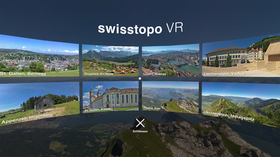
Using eight selected scenes, swisstopo VR will show the public the potential swisstopo’s 3D geodata harbours for virtual reality. swisstopo VR uses the game engine Unity.
- swisstopo’s 3D geodata -
The following swisstopo 3D geodata sets have been prepared to assist the development of the swisstopo VR app: swissTLM3D, swissALTI3D, swissBUILDINGS3D 1.0 and 2.0 and swissNAMES3D. The product swissTLM3D is a detailed and comprehensive topographical landscape model of Switzerland which includes both natural and artificial features as well as name data in vector form. swissTLM3D is highly accurate and incorporates the third dimension, making it Switzerland’s most precise and comprehensive 3D vector data set.
- Contact -
Federal Office of Topography (swisstopo)
Seftigenstrasse 264
3084 Wabern
Switzerland
[email protected]
www.swisstopo.ch
- App development -
Ateo GmbH